Kaipokok Bay (Postville, Nunatsiavut)

Use this section to set the units you would prefer to use when viewing SmartAtlantic data.
Note:
SmartAtlantic data will be converted to use the desired units for
display and charting
purposes only.
Any data obtained via the Data Request feature will continue to use the
units specified in the
dataset.
Kaipokok Bay (Postville, Nunatsiavut) Station Info
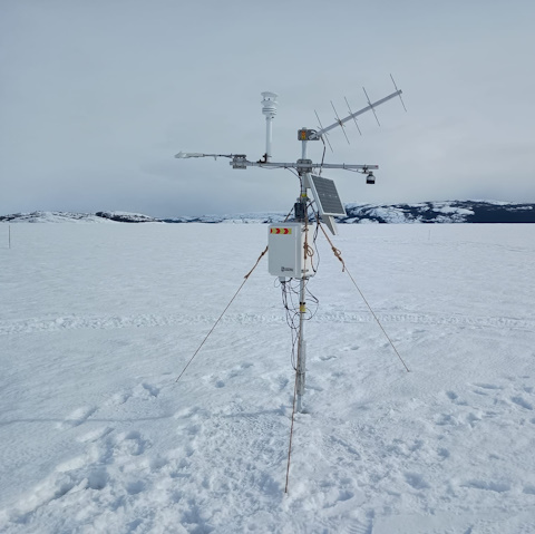
A 1.8-m tall weather mast is installed on the landfast ice in Kaipokok Bay, near Postville, between Woody Island and Pugaviks Island (54.96061 N, 59.67184 W).
The Kaipokok Bay weather station is part of a sea ice monitoring project led by Dr. Eric Oliver and May Wang at Dalhousie University in partnership with the Nunatsiavut Government and the community of Postville. It was established in January 2024 and is active only during the ice season (approx. mid-January to mid-April).
The goal of the project is to study long-term changes to the sea ice, ocean and weather, with a specific focus on how heat is transferred to and from the ice.
Funding for this project was received from the Crown-Indigenous and Northern Affairs Canada (Government of Canada) through the Marine Conservation Targets Grant.
Other measurements (and instruments) recorded at the ice monitoring site include:
- Snow and ice temperature (Sea Ice Mass Balance Apparatus (SIMBA))
- Ocean currents (Acoustic Doppler Current Profilers (ADCPs))
- Ocean temperature and salinity (Conductivity Temperature Depth loggers (CTDs))
- Ice salinity
- Snow density
For inquiries please contact Eric.Oliver@Dal.Ca